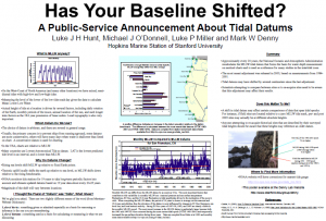
I recently dredged up an old poster on tide heights and tidal datums that several of us put together back in graduate school and presented at the Western Society of Naturalists meeting in either 2003 or 2004. This was a hot topic (for 5 or so people) at the time, since the national tidal datums for the United States had all just been updated.

This poster discusses how the tidal datum, i.e. the location of the zero tide level, is reevaluated and adjusted every ~20 years by NOAA. This is due mainly to issues such as rising sea levels and sinking or rising land masses (particularly due to glacial rebound from the last ice age). Because the primary economic driver of NOAA’s tide predictions is the need for safe, reliable information about how deep navigable coastal waters might be for boats to pass through, it is useful to adjust where the zero-tide level is once in a while. The last major adjustment was implemented in 2003.
This is also relevant for researchers working in the intertidal zone that work with both historical and current-day records of shore heights for their study sites. If you are re-surveying old study sites from the previous tidal epochs, the tide predictions that tell you when your location is submerged or exposed will potentially have shifted, though often by just a few centimeters.
For example, if you were measuring at an old site in Monterey, CA, that was previously listed as being at 1.0 m above the zero tide level (Mean Lower Low Water) in the 1960’s, that same location on the rock face would now be considered to be roughly 0.92 m above MLLW today, because of the upwards adjustment in the tidal datum for Monterey. The change differs for other locations along the coast, as shown on the poster.
Another way to think about it: if your old site’s height was guesstimated relative to the still-water tide height off of an old tide chart in the 60’s (for example, an old transect line on the shore was said to be 1.5m above the predicted zero tide level on a calm day), a modern copy of the tide chart would have you arrive at a different height on the rock, because the modern-day zero tide level is slightly higher (in Monterey).
And if the “datum” references in this post have been bugging you, please see the poster for an explanation for why datum is actually the correct term of art in the discussion of tides.